


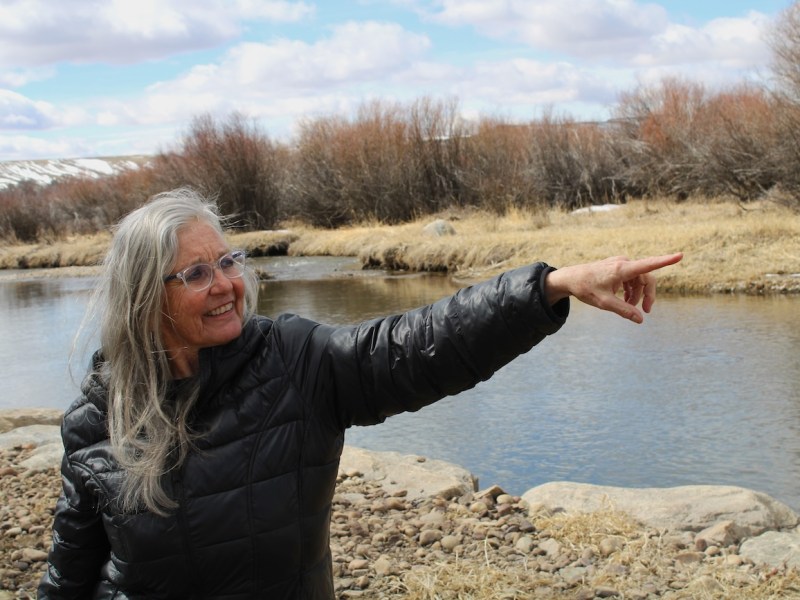
Wyoming’s water chief wants emergency funds for hydrologists to measure flows in the state’s portion of the troubled Colorado River Basin, documentation he said is vital to preserving irrigation and other uses.
State Engineer Brandon Gebhart asked for $167,210 in supplemental budget funds, a piddling amount in the world of western water finances, but a critical sum necessary to launch the work this spring. He called parts of the proposed allocation an “emergency,” a designation that would enable disbursements to begin this fiscal year.
Among other things, the money would employ three full-time hydrographers to measure flows in the Green and Little Snake river drainages. The total figure covers money specifically directed toward Colorado River issues as Wyoming girds to protect irrigators and other water users.
Climate change and drought have upset basin flows and could upend allotments agreed to in the seven-state 1922 Colorado River Compact. That, in turn, could threaten Wyoming’s water rights.
“Mandatory reductions are pretty much a hard ‘no’ for me.”
Brandon Gebhart
“What we’re seeing is an increase [in] demand and a decrease in supply,” Gebhart told members of the Legislature’s Joint Appropriations Committee in December. “This likely means that our downstream states will have a greater interest in our water. Being a headwater state, it’s somewhat concerning.”
Upper basin states — Wyoming, Colorado, Utah and New Mexico — don’t agree with lower-basin users in Arizona, California and Nevada on how or whether to reapportion dwindling runoff that supports some 40 million people. Lower basin states want equal “one-for-one” cuts shared between the two divisions, Gebhart told irrigators last summer.
“Mandatory reductions are pretty much a hard ‘no’ for me,” a position shared across the upper division, Gebhart said.
Enhanced storage
“You’re not going to hear me in the press,” Gebhart told irrigators in Baggs last summer, but he’s outlined Wyoming and upper basin states’ position in several public meetings.
“We have less water than was ever anticipated when the compact originated,” Gebhart said. “The last 22 to 24 years are the driest, the least flow in that basin in over 1,000 years.”
The 1922 Colorado River Compact requires upper division states to allow 75 million acre-feet to flow past Lees Ferry, a gauging station just below Lake Powell’s Glen Canyon Dam, during a rolling 10-year span. Wyoming’s responsible for about 14% of that and, conversely, can use a similar percentage of what doesn’t run past the gauge.
Wyoming believes it hasn’t fully tapped its 1922 share and is pursuing three significant water storage projects to fulfill its rights. Those are at New Fork Lake, Fontenelle Reservoir and a proposed reservoir on the West Fork of Battle Creek above the Little Snake River.

Those plans would primarily increase water available to Wyoming irrigators and other users. Enhanced storage could also help fulfill Lees Ferry flow obligations, but Gebhart has made clear Wyoming is unwilling to contribute “more than what we’re already under obligation for in the compact,” unless that comes from conservation, including paid-for voluntary conservation.
Unlike the lower basin states that rely on Lake Mead, “we don’t have a large reservoir to supply our releases,” Gebhart said. Instead, Wyoming’s Colorado River Basin reservoirs provide only late-season irrigation, not years of backup.
“We’re dependent on whatever Mother Nature gives us [in] the run of the river,” Gebhart said. But, “the hydrology is drying out. We have less.
“We already suffer what they refer to as shortages,” he said. “Every year we go out, we regulate off users because there’s not enough water.”
Enhanced measurements
For Wyoming to protect its share, it needs to know how much water diverted from rivers makes it to agricultural fields. Without documentation that can withstand legal challenges, others might say Wyoming is consuming more water than it puts to beneficial use.
Beyond what water makes it to the alfalfa field, hydrologists could also document how much leaks from irrigation canals and flows back to the main waterway, thereby remaining in the system.
They can also measure how much of the water applied to fields eventually seeps back to a river or stream and down toward the lower basin. Rules of thumb that previously served water managers may not stand up in court.
For example, Wyoming has long operated its dam, reservoir and irrigation systems, assuming that half of the water applied to a field eventually rejoins the river as return flows. The state also acknowledges that up to 80% of the water running through a canal, depending on its construction and underlying geologic composition, can leak before arriving at its destination.
The amount of seepage and phreatophytic losses — canal-side, plant-used water — is an “area of agriculture data collection that need[s] to be updated and verified,” the U.S. Bureau of Reclamation said in 2022. Toward that end, Wyoming recently directed a study on canal loss from long and porous irrigation aqueducts.
More hydrographers and scientific measures would buttress Wyoming’s claims.
“We recognize that it is very tough for us to conserve a large amount of water,” Gebhart told irrigators last summer. A paid-for voluntary conservation program would allow the state to put water savings on a ledger. In Gebhart’s words, Wyoming would “stash it away in a federal facility with our name on it until it’s needed,” to satisfy 1922 compact requirements at Lees Ferry.
Although upper and lower basin states are at odds, Gebhart said it’s not too late to reach a consensus on how to operate the complex system before the federal government steps in and forces a compromise. Those negotiations, if they happen, are not going to be done in public, he said.
Despite his reluctance to make direct statements to the press, that “doesn’t mean that we’re not here,” Gebhart said.
Forty million downstream users vs 550,000 Wyomingites. Hardly a contest.
It is not too late in the water rights issue for lower and upper basin water users to practice more water conversation measures. The American Indians of the upper basin states might possibly hold the most senior waters rights but given the history of how the federal government has dealt with the American Indian treaties those rights will be another un-kept promise. Given Wyoming’s arid climate and the shortage of adequate snow fall it seems unreasonable to increase storage in a few dams as evaporation rates can account for 25-30% of the total consumptive use of surface water in arid regions. In some cases, annual evaporation losses can exceed 40% of the water stored in reservoirs. The state water commission does not have the money to pay for monitoring stations installed on the many ditches and laterals that are providing surface water for hay, gardens, or cash crops. Lining ditches would be monumental and expensive undertaking. Conservation requires a little effort but cost nothing.
Interesting figures concerning the loss of water in open ditches and canals. I’m aware of federal grant money for lining of ditches and/or switching to buried pipe. One of our irrigators went through a complicated series of 50/50 matching grants in order to convert his low yield hay field into highly productive acreage. It was costly and took several years to complete. Irrigation districts can also apply for grant funds in order to lesson the water losses in the main ditches and canals. I remember seeing several ditches between Riverton and DuBois along the highway where the ditch cut through sand deposits and/or coarse gravel – the water loss must be atrocious when the ditches cut through porous alluvium.
There’s a lot of work which needs to be done reducing our loss of irrigation water – it will be very expensive and can only be accomplished over a 20-50 year time frame. There must be at least 50/50 matching grant money or else the individual irrigators or irrigation districts just won’t be able to afford the capital expenditure. I assume the Farm Bill contained federal funds for water distribution improvements – that would be through the USDA programs. It can be done – the SW states have already made major improvements in their water usage – particularly in southern California in the Imperial Valley irrigated lands. There’s a strong argument that Wyoming users shouldn’t have to pay the cost of reducing our irrigation water losses just so the SW states covered by the Colorado River compact can continue to use water at the existing rate – hundreds of golf courses and thousands of swimming pools. Shouldn’t the SW users pay a portion of the cost of improvements to water distribution in Wyoming??? That’s where the federal funding becomes extremely important.
There used to be many stream gaging stations in Wyoming but these were abandoned years ago as we found when attempting to obtain flow records for the north slope of the Uintas. Someone should look into this history and see if it was a cynical political move to stop this data collection, lack of funding and the reasons for that, or other cause.
I just find it ironic that we now see the need.
When I was in grade school in California during the 1950s it was commonly accepted knowledge that there wasn’t enough water in the Colorado River to support all the claims for water from it. The thing that kept it from going into crisis was that claimants weren’t taking their full allotments. Today most claimants seem to want all they can get and the supply limitations have become an issue. Water that stays in the basin is partially returned to the river, water that leaves the basin is gone.
Water flows uphill to money.